Garmin GPSMAP 86Sci, schwimmendes Hand-GPS mit Tastenbedienung, vorinstallierte BlueChart G3-Küstenkarten und Inreach-Satellitenkommunikationsfunktionen, Streamen von Bootsdaten von kompatiblen Kartenplottern GPSMAP 86sci Hand-GPS

Brand:Garmin

3.2/5

904.22

Mit dem GPSMAP 86Sci-Handheld können Sie souverän loslegen. Egal, ob Sie einen Tag lang angeln, segeln oder kreuzen, Sie können beruhigt sein, weil Sie über ein Backup-Navigationsgerät mit Satellitenkommunikation und interaktivem SOS verfügen. Dieses Premium-Handgerät schwimmt und verfügt über ein auch bei Sonnenlicht gut lesbares 3-Zoll-Farbdisplay. Darüber hinaus macht es die drahtlose Konnektivität zu einer virtuellen Erweiterung Ihres Bord-Marinesystems und sorgt so für mehr Aufmerksamkeit und Komfort.

Keine Einheiten verfügbar
Der optionale Wettervorhersagedienst in Reichweite bietet detaillierte Aktualisierungen direkt auf Ihrem GPSMAP 86i-Handheld mit einem Satellitenabonnement. Mit einem Satellitenabonnement teilen Sie Ihren Standort mithilfe der GPS-basierten Standortverfolgung mit anderen. Mit einem Satellitenabonnement lösen Sie ein interaktives SOS an die rund um die Uhr verfügbare Such- und Rettungsüberwachungszentrale aus. Der einstellbare GPS-Filter sorgt für gleichmäßige Geschwindigkeits- und Kursanzeigen bei Wellengang. Funktioniert als Fernbedienung zur bequemen Bedienung Ihres Garmin-Autopiloten und Ihrer Fusion Marine-Produkte; Laden Sie zur Aktivierung kostenlose Apps aus unserem Connect IQ Store herunter. Bleiben Sie in Kontakt mit erreichbarer Satellitenkommunikation und bidirektionaler Textnachrichten über das 100 % globale Iridium-Satellitennetzwerk (Satellitenabonnement erforderlich). Die vorinstallierten Bluechart G3-Küstenkarten enthalten die besten Garmin- und Navionics-Daten. Streamen Sie Bootsdaten von kompatiblen Kartenplottern und Instrumenten, um Ihre Marinesysteminformationen zu konsolidieren. Das wasserfeste, schwimmende Design, das bei Sonnenlicht sichtbare 3-Zoll-Display und die Tastenbedienung sorgen für eine einfache Bedienung auf dem Wasser.
Batteries 1 Lithium Polymer batteries required.
Brand Garmin
Color Black
Customer Reviews 4.2 4.2 out of 5 stars 171 ratings 4.2 out of 5 stars
Human Interface Input Buttons
Item model number 010-02236-02
Item Weight 1.6 pounds
Manufacturer Garmin
Map Type Nautical
Model Name 010-02236-02
Mounting Type Wrist Mount, found in image
Other display features Wireless
Product Dimensions 1.7 x 2.8 x 7 inches
Screen Size 3 Inches
Special Feature Bluetooth
Special features Bluetooth
Sport Fishing
Vehicle Service Type Boat
Whats in the box GPSMAP 86sci handheld with BlueChart® g3 for the U.S.; Powered Mount; Lanyard; USB to Micro USB cable; USB to 2 pin cable; Mounting hardware; Documentation See more

3.2

9 Review
5 Star
67
4 Star
13
3 Star
6
2 Star
5
1 Star
9

Schreiben Sie eine Bewertung

Ihre E-Mail wird nicht veröffentlicht. Alle Pflichtfelder sind mit gekennzeichnet*

Scritto da: Joseph Chan
Good to have inReach function
The inReach function is good. The device works fine like the other Garmin handheld device I have used before. Only one suggestion: the different main functions ( like Map, Main Menu, Trip Computer, Messages etc...) needs to scroll with the 'Quit'/Page key. If I press the Quit/Page key too fast, the function is passed, I need to press the Quit key again for next round the function appears. If all the main functions can be shown on a single page and selected with arrow key like other level of function selection, it will be much better.
Scritto da: Alfred Faber
Staying in touch us what’s important
The device is really sturdy and it works well. Things are a bit slower with satellite, but that’s not the device - it’s the whole deal. I recommend…
Scritto da: Julianne Veal
Great tool
I bought this after getting lost in the mangroves for several hours while out paddling. My phone went dead and at dusk my husband called 911. I found my way off the water and looked up and there was a helicopter looking for me. Never again! Just be prepared to spend another $250 or so on a good map, plus a subscription. Worth it for me! Some of the reviews mention that it takes a time investment to learn how to use it. Yes, it does. But honestly it's not that hard if you value the freedom that it gives you! My experience with Garmin tech support has been very good. With the subscription, I can paddle alone and it will send tracking info to my husband during my entire paddle. I can set waypoints and find my way back home easily. I can also plan routes ahead of time and follow those. Plus it has an SOS button that will call the cavalry in case of a real emergency. It's just what I needed.
Scritto da: dcl
Rugged, quirky, user experience anything but seamless
Rugged, with just a few buttons, this is made for punishing environments. In the cabin of a ship, with little internet access, the user experience is very fragmented. You will need two smart phone or tablet apps, two Garmin web sites, a Garmin desktop app, and fairly frequent internet access to effectively use this. It does not share GPS position over NMEA nor Bluetooth with other shipboard devices. It keeps position to itself. Messaging will be with the explore app, but the app not having position, the position will be missing from the message (even though the device, which knows position, is doing the actual sending). The cradle does not hold the unit firmly enough. In the moving boat, it jiggles disconnect. Some very carefully applied epoxy to build-up the indent on the back of the device solved this. The device auto-shuts off when removed from the cradle; so, two careful button presses each time you take it down. This gets old. This feature protects the battery from going dead on power loss. An any-key response to keep it awake would be better. Or better, a setting that disables this behavior. When it powers-down, the current tracking session is interrupted. The interaction between tracking and recording is mind boggling. They try hard with dialogs about the interactions that have to be acknowledged over and over. Better would be one or the other with a switch to control the live tracking. Most of the other function overlaps. Saving an "activity" creates a track on the map distinct from the tracking track, which is always saved. One shows up in "activities" and the other in "tracks". See what I mean? Little bugs. The time zones aren't programmed correctly. My unit was an hour off for a while along Pacific coastal Mexico. There's no time zone setting that will simply display the UTC value from the GPS satellites. Below about 1.4 knots it shows heading 180 degrees off (reversed).
Scritto da: J. Miller
86s says it’s type nautical but includes no nautical maps
Incredibly confusing advertising. Turns out it just has the base map even though it has marine and nautical in the description. Turns out only the sc has the nautical map
Scritto da: Birdwatcher35
App not great
The app is not great it's geared to fitness not marine, not useful. Unit is fine.
Scritto da: Jason
So glad it floats!
This is a great hand held device. I took it moose hunting and dropped it in a stream, luckily it floats so I was able to just easily reach down and grab it.
Scritto da: Pippinm7
Excellent
Light weight-covered in a tacky rubber that makes it easy to hold on to when moving in a boat Battery Life- is over 24 hours of use in GPS. I accidentally forgot to turn it off after a full 8 hours on the water left it on the counter picked up the next day and used it for the entire day on the water again with no charging. Bread Crumbs-I love the bread crumbs feature and live tracking I wish-It had the same display as the in boat garmin gps. it would make using the device easy and take no getting used to Yellow Tape-I put a piece of yellow electrical tape on the antenna, so if it goes over board it will be easy to see regardless if it is face up or face down in the water. Floatation-floats both face up and face down.
Scritto da: Wandering Academic
Excellent tech, with the usual (updated: serious!) complaints about integration and auxiliary costs
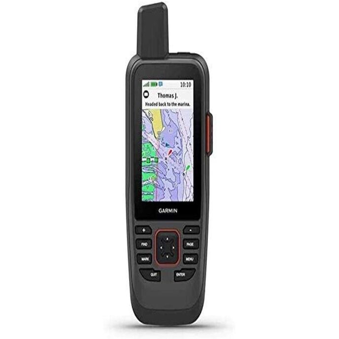
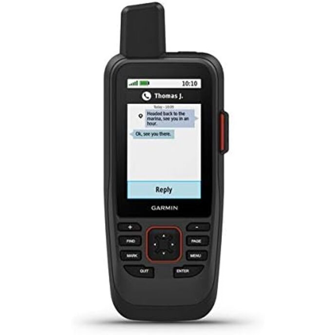
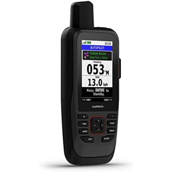
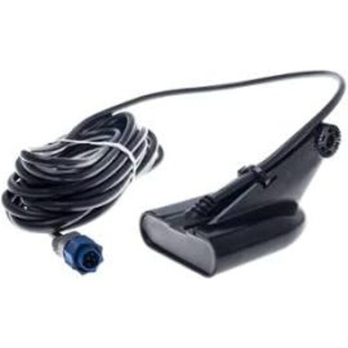
Garmin handhelds are pretty much the only game in town for marine gps, and this device delivers on the technical front. The tracks are consistent and accurate. The screen is clearer and bigger than the preceding GPSMAP 78, the controls seem to me far more intuitive, and the battery life is much, much better (although still no touchscreen, but given the marine application, that makes sense: you want this thing to take some watery abuse, and a touchscreen complicates that). I re-activated my inreach account for this device, and that brings me to my constant complaint with Garmin: their tech is usually solid. Their product integration? Meh. There's always some annoying little thing that makes life more complicated than it needs to be (example: the Earthmate map with the old inreach devices had marine nav charts. Very cool. This device? Same inreach account, but now the device integration uses Garmin Connect and the Explore app, with no marine charts. Another example: using Garmin Connect for managing multiple adventure wrist and handheld devices makes sense, but the maps loaded on said handheld devices load and sync separately, and that makes management, and especially updates, confusing and tedious). And of course Garmin's InReach accounts are expensive. Not that this device needs the InReach to be a good handheld chartplotter, but if you're out of cellular range it's good to have ... and it costs: a more expensive device, and pricey monthly and annual fees and charges. Another reviewer mentions that this device isn't compatible with Garmin's One Chart integration. That's true, very annoying, and worse still, the incompatibility isn't obvious until you've scoured a lot of the help files and FAQs (and customer complaints), so be careful before you purchase maps or updates. It's a seemingly arbitrary feature too: is it really so technically difficult to bring handhelds into the Garmin chartplotter family for shared maps and the Active Captain app!? What's more, it reeks of a petty cash grab. Still, for some bizarre reason I keep being charitable with Garmin, and not assuming they just want to wring money from their faithful users. I guess it's because the tech is always solid. Update: I had this device out while escorting a marathon swimmer on an 18hr crossing. I was using the Inreach tracking services, but the live tracking stopped mid-swim. Disconcerting for those following the tracking in real time, although luckily we also had a SPOT track running as well, so we could broadcast that instead of the Garmin track. What explained the Garmin failure? No idea, but I suspect it happened while trying to use the handheld for ITS ACTUAL JOB! navigating. So, Garmin, that's not a great look: I either use this ridiculously expensive device as a navigation tool, or as a tracker, but trying to do both risks some silly software compatibility fault!? I'm downgrading my review score simply on this basis: a company with this much experience and dominance in the Marine sector simply shouldn't market a device that fails so randomly. I notice now that Garmin has revamped the old GPSMAP78 series, so I may sell this overpriced handheld, and instead use my old Garmin Inreach mini for tracking, and buy the new GPS-only marine handheld for navigation. Oh Garmin.

Verwandte Produkte

hot

Entdecken Sie unser internationales Netzwerk

Wir versenden in 28 Länder, über 200.000 Produkte. Bleiben Sie auf dem Laufenden, abonnieren Sie den Newsletter.

Array